Friday, January 24, 2014

Mid Bay Island

Welcome to 2014.  "Congrats on living another year!" a friend told me when I saw him after the new year holiday break.  We hadn't been able to get out to the boat much in November or December and the time we did have available was usually crummy weather.  Galveston and Trinity Bays are quite shallow, averaging maybe 10ft of depth.  This sort of shallow water sailing is enough to make sailors from the northeast or the pacific northwest break out in hives but for us, it's all we've got.  In fact, if I see double digits on the depth transducer it might as well be the Marianas Trench.  When we have a winter front blow through it is usually followed by a strong north wind for a couple of days.  This causes water to essentially be blown out of the bay and can reduce our already shallow depths to staggeringly low numbers.  So unless you operate an air boat it's not always good seamanship to be out and about for recreation.

What Galveston Bay boaters consider deep water.
But 2014 started nice enough.  The stars aligned a couple of weekends ago and we had only a mild front that pushed through, promising a steady north wind and 70 degree temps, but not so much as to make depth a problem.  The plan was to do what we always do, try to take over the world... sorry, wrong blog.  The plan was to sail the day, interrupted by anchoring somewhere for lunch.

Jessica, the two girls and I piled into Word Play and set out.  Watching the depth, going out the channel from the Marina, it was shallower than I've ever seen but we had a good 11" of water under the keel.  Plenty!  I passed a Sheriff on the way out, cruising in his boat going the other way, and sweated a bit.  I should say at this point that I still don't have registration stickers on my boat.  I only just got my USCG documentation, 9 months after submittal!  The whole time I'm thinking to myself "act causal, act casual!" but I'm sure, in reality, looking like I'm smuggling a boatload of mattresses with their tags cut off or something.  Fortunately he was driving and talking on a cell phone so there's a good chance he wasn't even aware he was on the planet earth.

Once we got out into the bay we were greeted by a shock.  Being the first weekend day in a while promising good temps, good wind and sunshine, I believe all boats in the Texas, New Mexico, Arkansas, and Oklahoma area decided to launch.  You could have walked across the bay.  It was a hand full but my only real nailbiter was when a little racer with a small crew decided to cross my stern, tack back 180 degrees, taking right of way, and shooting across my bow.  So technically he had right of way after he tacked but it was clear that a) we were not in a regatta, b) I am not a race boat, c) I was single handing d) he had the rest of the bay and didn't need to use the water molecules directly in front of me.  It was exceptionally poor decision making on their part to risk collision like that and caused me to have to crash gybe to avoid a hit.  So after some vigorous yelling in which I opined on their collective intelligence and genetic lineage, I decided that we were going to Trinity Bay.  I don't know if everyone knows something I don't but Trinity Bay is always empty of pleasure craft.

Oh, so that's why no one is ever over here...
We took the North Boaters Cut across the ship channel which takes you disconcertingly close to the spoil bank / island (called Mid Bay Island by some) being created in the northern part of the bay.  This is a really interesting feature  having been built a decade ago both as a repository for dredging material and as a marsh habitat for wildlife. Since the ship channel passes right by the island, the perimeter wall was designed so that ship wakes would provide the energy needed for water circulation in the marshes, located in the interior.  The upland areas were seeded with prairie plants to see how they would grow on dredged material.  Most recently, due to the need to find space for dredged material, I believe the whole structure is slated for conversion to an upland (i.e. above water) feature.   The whole thing is around 600 acres I think; so not insignificant.
 

North Boaters Cut is the red line above the island.  We came from Kemah way over on the left side of the screen.

Since we had a wind from the north we tried a new anchorage.  We went around the side of this man made island and anchored in the shelter of its south end.  This turned out to be a fine spot to have lunch, and the sand on the island warmed the north wind that blew across the top and made for a very nice stop.  My only complaint is that the wakes from the ship channel traffic would occasionally reach here and roll us a little.  So maybe not a good place to spend the night but a fine day stop.

I worried about subsidence from the island so I gave it a wide berth.


On the way back Jessica took the helm and, as always, turned things into a competition on who could hit the highest top speed.  I myself, being above that sort of foolishness, took the helm and proceeded to whip our little Jeanneau 379 up to 8.5 knots, heeling over about 25 degrees and eliciting a constant stream of yelling and vitriol from the kids down below.  I win.

Monday, October 21, 2013

Moody Gardens by Sea

Our oldest daughter had a three day weekend coming up which is kind of a big deal now.  She's in a new kindergarten and apparently it is frowned upon (I hope you can see me rolling my eyes because I'm doing it as hard as I can) if we take her out of school every Friday for sailing, or as I call it, therapy.  And those shrewd rapscallions so far haven't bought on my explanation that my daughter has Count Choculitis and requires periodic Fridays to recuperate.

For several weeks now we had planned to try to do a two night stay, destination cruise in our boat Word Play.  The question was where.  Jessica and I had scouted a little restaurant/marina over on the Intracoastal Waterway side of Crystal Beach called Stingaree but the weather forecast for that weekend was a little dodgy and certainly wasn't going to be beach weather so we defaulted to Jessica's choice: "Whatever is the most expensive weekend sail destination, let's do that."  I jest of course; we chose a nature conservancy / entertainment venue called Moody Gardens.  When making the reservation I was pleasantly surprised to find that the rate of $2.25 per foot of boat length covered two nights.  This is essentially buy one get one free.

You had me at free.

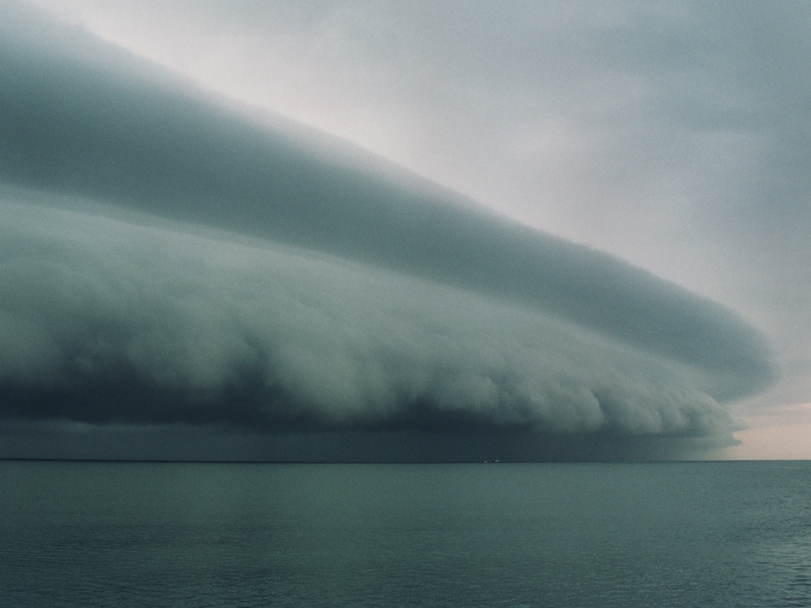
So it was off we go.  We actually stayed the night on the boat Friday so that we could leave early in the morning and hopefully have some of the day left at our destination after the five hours in transit I was forecasting.  When I woke up and went outside, the air seemed thick and heavy.  Looking southwest you could already see build ups forming off shore:

What's that saying, "red sky in morning, sailor has a good sail"?

Oh wait, that's not it.


Leaving the Kemah channel it was dead calm on the Bay.  Everything was a sort of purple / red out and it was really quiet, which I found eerie.  And as soon as I pointed the boat to the heading that would take us to the ship channel and onward to Galveston, this was in our way:

Of course it was.

Shortly thereafter the wind kicked up to about 30 knots right on the nose which continues our unbroken streak of having head winds on our journey.  It turned out to be a pretty good little storm cell although we only got a glancing blow since I was able to do a little southing to get around it.  Looking down in the cabin all the girls were down there in their shirt sleeves playing games.  Meanwhile I've got on my offshore life vest and other accouterments, looking like the fisherman on the Gorton's fish sticks box, getting a complimentary power washing of my face.  On the bright side, I counted that as my weekly bath.  Fortunately that ended up being the only real build up we had to contend with.  A sort of path opened up right where we needed to go and the sun even came out.


Our course took us southwest to merge into the ship channel.  The way south, out of the bay, is crowded with oyster reefs, shoals, platforms and gas wells.  The only non bowel clenching way to navigate this, if you are in a sailboat of moderate draft or worse, is to take the ship channel.  That sort of brings its own set of issues though, given that you're sharing the road with vessels who carry a life boat longer than you are and who probably can't even idle as slow as my max speed.  All this culminates at
the confluence of the Intracoastal Waterway, the Houston Ship Channel, the Trinity River Channel and the Texas City Channel.  Two out of these  are in the top 5 of busiest waterways in the USA.  In reality it probably wasn't that bad.  The large impression it left on me was likely due to the fact that I was a relative greenhorn at navigating and communicating with a large amount of commercial traffic.  I sort of found it akin to a situation where approach control for Houston airspace was handled via unicom, for those of you reading that are aviation inclined.


Our route took us up a short section of the Intracoastal Waterway which was relatively straightforward other than figuring out the hard way that barge traffic is much more accommodating on VHF 13 rather than 16.  A left turn after the causeway bridge and we were in the Offatts Bayou Channel.  Why is it called Offatts?  I heard a story that when Galveston first had rail service there was a stop at the bayou so Off At the Bayou became Offatts.  I like that better then the one about the guy named Offatt who settled there so I choose not to propagate the latter.  Ok, so here is the part where I talk about almost
going aground which seems to be a common theme when I'm taking the boat anywhere.  Like a competent mariner, I had done my route planning and I had the latest charts for my route and so forth.  I had also armed myself with local knowledge and I knew that you had to be double extra sure to pass by Red Marker 28 or risk sure grounding.  Even so, that damned Red Marker 26A is the devil! I got to 24 and the next logical progression was Red 26A (we couldn't actually read the 26A at this point, we could only see that it was next in line.  We hadn't noticed that far off to the left was 26 which we needed to slalom around to avoid 1' deep water.  There were a bunch of red cones leading a path to 26 but in my feeble mind they were marking a channel into the new marina that has been built on the north side of the bayou.  If it wasn't for some blessed soul in a power boat that came zooming by making "shallow" gestures, our keel would have haplessly become one with the mud shoal dead ahead.  So fortune favoring us we turned and avoided that damned trap and made our way to the marina at Moody Gardens.  Incedentally I have found that Moody Gardens must have been named after the first arriving family that had two 6 year old or less daughters and a cuban wife and one poor husband, cooped up in one small Jenneau 379 for hours.

We were the only ones at the marina docks unless you count the 124x10^234 seagulls who apparently consider it their pooping area.  Aside from being a little isolated down at the docks, we actually found it a tremendous way to have an extended stay in the west side of Galveston.  We spent two days in the area doing touristy stuff.  It was tons of fun.  We'll definitely be doing this trip again.

Word Play at the Moody Gardens marina.

I told them not to cut those tags off the mattresses.


Going home was a beautiful broad reach in light to moderate winds.  A great end to a great trip.


Saturday, September 28, 2013

Double Bayou

(August 2013) Of all the places to cruise in Galveston Bay this one intrigued me the most.  Off the beaten path, tricky to get to, the promise of cheap but quality dockage.  Sort of the Shangri-La of the swamp?  So for our second real outing in Word Play we pointed her bow east, trimmed for a close reach and made wake for the metropolis of Oak Island.

Word Play sleeps at Watergate Marina in Clear Lake so taking a trip to Oak Island and the Double Bayou required a sail across a wide swath of the Galveston / Trinity Bay basin including crossing the Ship Channel.  Past dredging of the Houston Ship Channel has produced a spoil bank along its east side.  The depth of this seems to vary considerably due to underwater erosion and the likes and I have seen sailboats sailing over it seeming unaffected.  Still, given that my depth sounder gives me about .0001 seconds of advance notice of shoaling ahead, at any sort of reasonable speed, and given that I worry like an old lady, I always chose to stay in the marked cuts through the spoil bank. You have a few choices for cutting across the Houston Ship Channel in this regard.  The two most useful, if you are coming out of the clear lake channel, are the "north" and "south" boaters cuts.  These are marked and maintained channels north and south of the spoil island that is being slowly created in the middle of the bay.  The wind and your course generally dictates one cut over the other.  Because of an east wind, the south cut made sense this day because it put us at a better angle for the longer leg of the trip.  See NOAA chart 11327 for these cuts.

Both cuts are shown here along with the insane number of hazards and navaids that exist in this area.
So having set a course, the kids, the first officer and the dog all settled in for a slow boat to the swamp.  After just exiting the south boaters cut we found ourselves in the middle of a regatta.  Not being familiar with any local racing I thought all the boats off to my starboard were just sailing around.  Then they all began to gybe around a power boat and headed straight for us, lol.  So I ended up having to turn on the engine and motor sail to get out of their way.  We flew by the photography boat under sail and motor while they were shooting pictures of us!  I felt like that scene in Marry Poppins when she, the kids and Dick Van Dyke all get on those merry go round horses and accidentally end up in a derby and win it, haha.  I was mortified that I screwed up something in the race but since we don't have the boat's name painted on it yet I guess no one will really know who we were.  After that little bit of excitement we continued on to the outer markers for the Double Bayou channel.

Google Earth has an aerial view where you actually can see the channel. You can see how it dog legs to the left; that's at marker 12 which is to small to see in this picture.  If you stay between the marker behind you and the boat house on the north side of the bayou in your front, you should be lined up in the channel.

Unquestionably the hardest part of a Double Bayou trip is the sketchy channel.  I believe that the last time it was dredged approximately coincided with when my wife last cooked dinner.  It's actually pretty well defined right up to the last official marker, Red 12, then you are on your own.  Even so, once I got to two or three markers out from 12 I furled the sails and motored the boat at about 2 knots.  My thinking was that I probably was going to go aground trying to hunt and peck my way in, and if/when I did, I wanted it to be carrying as little energy as possible so I could back my way off.  I had Jessica, my wife, in the bow trying to scout the bottom which is an exercise in futility in Galveston Bay at the best of times.  The water seemed to be darker where I thought the channel was and more muddy where it was shallow, or so I thought.  Right after marker 12 I had Jessica telling me to go straight ahead because it looked like clear water there.  So at about a knot and a half I proceeded as directed and watched as the depth sounder blipped 7.2ft then 6.9ft and then 2ft as I grounded the boat for the first time.  The bottom is thick mud so the keel just plopped right in.  I immediately backed us out and tried a slightly different route and proceeded to ground for the second time.  Because I was only going about a knot it was easy to back off again.  Then the five functioning neurons that survived my college days got with the program and I realized that the areas that were brown and looked like shallow water were actually the channel!  There is a lot of power boat and barge traffic that use this area and when they come in and out of the channel, they agitate up silt from the bottom.  The clear areas that look dark and deep are actually the areas that don't get boat traffic because they are shallow!  So having figured that out we made a left turn and pointed our nose to the boat house in the distance and headed in, again at about one and a half knots, with my heart at about 200 bpm and my butt cheeks clenched so hard that, had there been coal in there, it would have turned to diamonds.  As it turns out, making a left from marker Red 12 and pointing towards the boat house was perfect and we had over 7' of water under the hull the whole time.  Now I should say that before I went in to the channel out in Trinity Bay that I turned on the tracking function in my chart plotter.  This proved very useful because once I got in all I had to do was follow the same track (minus all the shenanigans that got me grounded) to get back out.

Oak Island community docks.  Don't forget your fenders!

Once you get into the bayou itself there is plenty of depth.  For this trip we intended to stay at the town marina.  Another option that is popular is to take the right fork in the bayou and motor back into the scrub land and tie off to the shore and relax in solitude.  So having found the town docks I attempted to bring the boat in stern first like how we dock at our home marina.  This provided immeasurable entertainment to a number of people nearby fishing since a) I am terrible at this and b) the water was too shallow to get my rudders back more than about half way to the bulkhead.  In fact in the process of her trying to fend us off the dock at a weird angle Jessica lost her balance and barely hung onto the dock as I floated away.  This event alone, I believe, has guaranteed that I will spend my golden years in a nursing home rather than being lovingly taken care of by my wife.  After taking a moment to hide all the accessible items on the boat that could be used as a weapon against me, I docked bow first and Jessica re-boarded.

After tying off you pay the overnight fee (a bargain at $35) to the little market east of the docks.  I did that while Jessica took the kids to play at the playground in the adjacent park.  Later we all went to eat at The Hurricane Club, a little greasy spoon type of joint near the aforementioned market.  They had a good selection of local sea food and for someone who loves anything fried, I was in heaven.  It was a fun little spot and everyone was nice as can be, even though we had two tired kids going nuts in there.

You're darn right! 

All in all we found Oak Island and Double Bayou a charming little spot to spend an evening.  The next day I used the the reverse route from coming in with no incident.  7' of water the whole time.  Then an easy sail across the bay and more marriage testing docking maneuvers and we were home!

Homeward bound.


Tuesday, September 24, 2013

Getting the Kids Onboard

To our two and five year old girls it doesn't take much to spark an adventure.  So when something like a sailboat comes along, to them, it's big time.  Heck, to me it's big time.

They wore their life jackets around the house for a week after we took delivery of the boat.  I believe there was an incident involving our two year old refusing to take it off, even when faced with a trip to the grocery store with mom.  And that's why we're not allowed into Kroger anymore.


It is not uncommon for them to ask if we can sleep on the boat tonight.  This question usually gets posed on a Tuesday at 7:00pm.  Of course my response is "awesome, let's go!"  This is shortly followed by my wife raining blows down upon me since the girls (and maybe me) are inconsolable when learning that it's bed time in our boring landlubber beds.


Sailing Vessel 'Word Play'

So this marks the start of what is intended to be a log, of sorts, of our sailing and cruising in and around the Galveston Bay area.  We are the Word family in S/V Word Play (pun intended), a 2013 Jeanneau 379.  She became part of the family in June of 2013 after a moment of weakness at the Southwest International Boat Show.  And by weakness I mean on the part of my wife.  We (i.e. I) had been looking for the past three years at buying a sailboat, using the time to slowly grind her down.  And, to my surprise, she said yes at the show so you better believe I grabbed the nearest broker on the dock and bought whatever he had for sale right then and there.  That whole wear her down and trick her into saying yes reminds me of the story of our engagement...